Exploration
EGSInc. offers a wide range of geothermal exploration services from the review of existing data, to the interpretation of satellite imagery and on-site technical surveys. These initial activities enable the geologists to better assess the geothermal potential of an area and provide the basis for establishing accurate geologic models on which further exploration efforts are based.Data Review
EGS evaluations include a thorough review the available published geological, geochemical, geophysical and reservoir documentation for past exploration programs in a project area. For most areas in the world, a significant volume of information has been generated over decades of geoscientific interest in mining, oil & gas or geothermal.
Remote Sensing
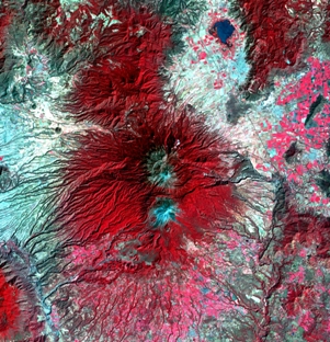
Satellite or multispectral surveys have been very useful tools for identifying the surface expression of geothermal systems based on characteristic mineral assemblages that result from hydrothermal alteration and in reconnaissance mapping or detailed structural evaluation via orthophoto, satellite imagery, SRTM, LiDAR. Remote sensing and spatial evaluation techniques have been used extensively in recent years to identify hidden geothermal systems throughout the Great Basin. Specific tools like the LiDAR imagery can be extremely useful in recognizing major structural elements that may control permeability in a potential system but are often by surface vegetation.
Geology
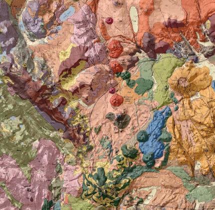 This phase is critical in the exploration phase, the geological mapping include the identification of major structures and lithologic/stratigraphic unit, as well as areas of hydrothermal alteration and thermal manifestations. It is usually the first work to be conducted on the ground and will give to the geologists the first elements to understand the structural controls and major features of the area.
Geochemistry
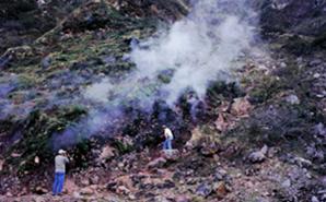 Geochemical sampling, analyses and result interpretation play an important role in exploration to determine the characteristics, origin and equilibrium temperature of the fluid constituying the geothermal reservoir.
EGS, Inc. will manage the geochemical study including the sampling, the laboratory analysis and the result interpretation and integration as part of the exploration of the geothermal resource.
Geophysics
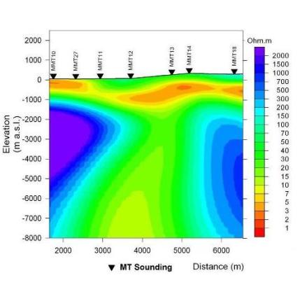 Geophysical data are crucial in attempting to understand the structural and stratigraphic controls on a potential geothermal system.
Numerous geophysical techniques can be applied on a geothermal exploration site (gravity, magnetics, MT, seismic, TDEM,…). EGS, Inc. has the experience to choose the most appropriate tools to a specific area and will manage and overview all the surveys before integrating the results to the model of the geothermal resource.
Geothermics
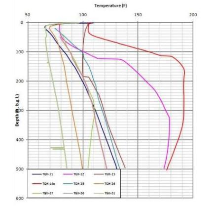 Temperature data are obtained from the drilling of shallow temperature gradient holes (from 10 to 1500 feet deep). Anomalies in the geothermal gradient will help locating the zone were the geothermal reservoir is shallower and give the first information regarding the extent of the resource.
EGS, Inc. team will compile existing and newly created temperature data to interpret the thermal characteristics of the reservoir at shallow depth and to carefully extrapolate temperature to greater depth.
Drill Target Selection
Select the site of the first drilling is a complex task, drilling a well is costly. EGS, Inc will, considering all the data compiled during the exploration surveys, select the areas most likely to encounter success during exploratory drilling.
Well logging & interpretation
 EGS has extensive experience in wellsite geology and the collection, logging and interpretation of cuttings and core from geothermal wells. Our work includes logging samples from wells drilled in low, moderate and high temperature geothermal systems in a wide variety of geologic settings. Specific work in volcanic environments includes wellsite geology on wells drilled in calderas, andesitic eruptive complexes, pyroclastic environments, flood basalts and hot spot or spreading center environments.